Miami21 zoning code the Miami smart city initiative City of miami new Urbanist zoning code is a direct decendant of the Smart Code, and design as a form-base code that includes more strict parking regulations and adressed transition to a more dense metropolis. Available/Permitted Useas: Residential, Lodging, Office, Commercial, Civic, Civil Support, Educational and Industrial. The miami21 include guidelines for density measure in Units per Acre and indicates Floor Area Ratio (FAR), Floor Lot Ratio (FLR) for each transect zone. FAR regulates floor area vs area of the lot. FLR regulates maximum building area allowed. Developments should be in compliance of all parking and landscape standars and regulations. Miami planning and zoning departments goal is to ensure sustainable development for the city, neighborhoods and its urban sprawl, with Transit-Oriented Development plans all along with streetscape Miami Comprehensive Neighborhood Plan (MCNP) According to the Department of Community Affairs (DCA): "The Comprehensive Plan address future land use, housing, transportation, infrastructure, coastal management, conservation, recreation and open space, intergovernmental coordination, and capital improvements" Miami Zoning code is a Form-Base zoning code example:Articles of the Miami 21 Zoning Code - Article 1 Definitions
- Article 2 General Provisions
- Article 3 General to Zones
- Article 4 Standards and Tables
- Article 5 Specific to Zones
- Article 6 Supplemental Regulations
- Article 7 Procedures and Nonconformities
- Article 8 Thoroughfares
Regulating Plan: Miami21 Zoning Atlas Adopted 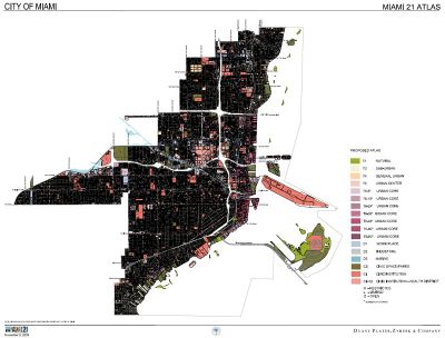 The Miami21 Zoning Atlas is the map that regulates designated areas and locations for different building forms available. Public Space Standards Defines the regulations for On-street parking, sidewalks, Public lanes, trees, furniture and any other public feature. Building Form Standards Functions, shapes, features, assemblages, configurations for buildings and its implications on the public area. Administration These are the guidelines for developments and projects application and review process. Definitions Glossary with set of detail information and concepts to agree upon. Miami 21 The Transect Zones: Rural > Transect > Urban, describe how regulations apply for each area to incentivice the transition from low to high density. Also controles how open spaces, streets, waterways, buildings: fuction and intensity, disposition, shape, form and configuration, parcels and land uses should be, to ensure they follow the code. What is known as "By Right". Note: variations among transect zones are (R-L-O) for Restricted, Limited or Open. - T1 Natural
- T2 Rural
- T3 Sub-Urban
- T4 GEneral-Urban
- T5 Urban Center
- T6 Urban Core
- D District
- D2 Industrial
- CS Civic Space & Parks
- CI Civic Institutional
Miami 21 zonig code Centers, Districts and Special Areas and Appendices Guidelines for comprehensive plans and development agreements and changes are included in the Appendices in Miami zoning code - Neighborhood Conservation District
- Waterfront Design Guidelines
- Midtown Overlay District
- Miami Worldcenter
- Brickell City Centre
- Design District
- River Landing
- Ransom Everglades
- Miami River
- ynwood NRD-1
- MANA Wynwood
- Miami Jewish Health
| 

